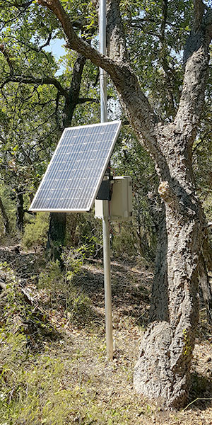
jetvision sensor station works independently without electrical grid via LTE
jetvision recently received a challenging request:
- The topic? The documentation of helicopter flights during blocking times or landings where they do not have a permit. In addition, the identification of unauthorized low-level flights over towns and cities. Precise data on flying objects, timing and frequency was needed to provide authorities with seamless facts from an independent source rather than incomplete guesswork.
- The place? A highly rugged area on the Mediterranean Sea. Civilization is all around, but at the necessary location for our technology, the terrain is difficult to access. There is hardly any infrastructure and no electricity supply.
- The idea? A jetvision outdoor sensor station with ADSB and FLARM including OPA5 GPS antennas, which use our MLAT server system to determine the precise real-time positions of the helicopters. Self-sufficiently operated thanks to a photovoltaic panel, buffered with a battery and LTE internet connection.
Precise and reliable hardware was required – and a quick, pragmatic solution was desired. The options regarding providers for this kind of flight tracking solutions are rare. That meant for us: challenge accepted! And just three months after the order was placed, the systems on the Mediterranean coast were in operation – a short time for a new type of solution on difficult terrain. The roads to the location were rocky, but the solution was smooth: We positioned our antennas and weatherproof sensor stations based on the jetvision Air!Squitter in places with a good overview of the terrain. The novelty for us: Due to the challenging topography and infrastructure on site, everything had to function independently and be remotely controllable.
And this is how it works: With a photovoltaic panel, the stations collect solar energy during the day, which is stored in state-of-the-art LiFePO4 batteries with a capacity for three to five cloudy days. The data is transmitted to the MLAT server via LTE and the charging status is recorded remotely. The functions of the Air!Squitter, such as ADS-B, FLARM and MLAT, can be switched off individually – depending on the available energy. We put the radio technology in a GRP housing to protect it from light, wind and water. Thus, we were able to install and run our hardware setup in the middle of the forest with a quiet conscience.
The result speaks for itself: maintenance-free systems that provide precise information on flight movements throughout the region. We can track each flight with great precision up to the landing point and even distinguish in which of the neighboring gardens a landing takes place. Notarial comparisons were made and certified. The authorities received a weekly report that was used as a comparison to official reports and caused quite a stir. In the end, there are three satisfied interest groups: the client gave thanks, the authorities have independent data for the first time, and jetvision has raised its technical setup for flight tracking to a new level: thanks to optional LTE and photovoltaic accessories for independent use, our sensor stations can now be delivered to the most difficult terrain to be.


